Brown bears, also sometimes known as grizzly bears, were once widespread in Washington State. Today, they likely number fewer than twenty resident individuals statewide. Even avid hikers of Washington’s mountains are unlikely ever to encounter one.
Rather than fruitlessly comb the Washington woods in search of our last, relict brown bears, I decided to head to where brown bears are still abundant: the salmon-spawning rivers of coastal BC. Halfway up Bute Inlet is the Orford River, a place so renowned for its seasonal, salmon-hunting brown bears that the local Homalco First Nation has set up a boat-and-bus-based brown bear tourism business.
To my way of thinking, it would defeat the purpose of seeing a brown bear to see one from a guided tour bus. I wanted to do it the right way: paddling and camping my way up Bute Inlet to meet the bears on their own terms. In addition, as long as I was in the neighborhood, I could swing through some of the famous tidal rapids in the Discovery Islands, which I had not visited in many years.
Route map. Reaching Elk Bay from Highway 19 normally requires a twenty-minute drive on logging roads, but I turned it into a forty-five-minute drive after I became disoriented by a disagreement between my topographic map and my phone map as to the existence or non-existence of certain of the roads.
The Orford River, halfway up Bute Inlet, was a two-day paddle from my launch point on Elk Bay. The journey to Bute Inlet was made slower by the necessity to coordinate my passage of the Dent and Arran Rapids with the turn of the tidal currents. It would have been possible to avoid the rapids and shorten the journey to Bute Inlet by launching from one of the boat ramps scattered around Quadra Island, but I preferred to wend my way through the channels and archipelagos the long way, following the same route the salmon were taking back to their natal streams.
Dent and Arran, the two rapids guarding the western approach to Bute Inlet, posed less of a threat than I had feared. During peak flow, the roar of the water rushing through Dent Rapids could be heard even from my campsite two miles (3 km) upstream, but I snuck past the rapids by squeezing through a narrow channel north of Dent Island, avoiding the worst of the current.
Arran Rapids was in the final hour of its flood cycle when I arrived. Even so close to slack time, Arran was still packing a lot of heat. I shot through the narrows at a speed of nine knots, startling flocks of Bonparte’s gulls who had congregated in the rapids in great numbers to harvest baitfish driven to the surface by the swirling whirlpools and boils.
Looking east up Okisollo Channel from Elk Bay. A week later, I would return to Elk Bay by heading west down this channel.
Looking north up Nodales Channel. In the midst of these twisty passages, it can be hard to distinguish what is an island, what is a bay, what is a channel, and what is part of the mainland.
Kayaking toward Dent Rapids in fog. Hearing the roar of the rapids without being able to see them through the fog made the passage seem even more menacing.
Entrance to Arran Rapids, shrouded in fog. The shortened days of September meant fewer windows each day during which the rapids could be transited.
View east down Pryce Channel, Gastineau Range to the left, West Redonda Island to the right. A kayaker could disappear for months into this maze of mountains and water.
The most difficult paddling conditions did not occur in the rapids, which were easily transited during the periods of slack water, but rather in Bute Inlet itself. Bute Inlet is famously subject to powerful inflow and outflow winds, funneled by the mile-high mountains that line the inlet. Kayaking guidebook author Peter McGee calls the Bute Wind (his capitalization) “the most famous outflow wind, possibly in the entire world.” Similarly, the Canadian Sailing Directions warn that “wind speeds of up to 60 to 70 knots can occur at the mouth of Bute Inlet.”
I didn’t encounter wind speeds anywhere near sixty or seventy knots, but I did encounter wind speeds well into the twenties. By sheer good luck, the inflow wind happened to be at my back when I entered the inlet and the outflow wind at my back when I departed, so I never had to fight a headwind. Still, even the tailwinds were no picnic. Choppy following seas tore one of my spare paddle halves clean off the deck, a loss I did not discover until I arrived to safety in the lee of Fawn Bluff.
One happy discovery in Bute Inlet was Moh Creek. At high tide, it was possible to paddle a few hundred meters up the creek’s outfall canyon. Dark, moss-covered stone walls closed in above my head, creating a secret green grotto, similar to Shark Creek in Clayoquot Sound or Goodman Creek on the Olympic coast.
The Moh Creek grotto was home to a pair of American dippers. The dipper is one of my favorite species of bird. Although it looks like an ordinary, terrestrial songbird, it forages by diving into fast-moving streams and running along the riverbottom, hunting for insect larvae. Dippers are usually found in the mountains—they were a favorite of the early mountaineer John Muir, for example—because steep mountain slopes lead to fast-flowing waters. Moh Creek’s unusual geography brings fast water right down to sea level, and with the water come the dippers.
Looking across Bute Inlet toward Mount Doogie Dowler. Along most of the shoreline of Bute Inlet, the mountains and even the streams plunge steeply into the inlet, leaving no beach on which to land a kayak.
Superb Mountain on the left, Mount Sir Francis Drake on the right. I scanned the slopes for mountain goats but did not spot any.
Royal Canadian Air Force CF-188B Hornet from 410 Tactical Fighter Operational Training Squadron, making a low-altitude run down Bute Inlet. This jet’s stores consist of a CATM-9M Sidewinder captive air training missile, two FPU-12/A 480-gallon external fuel tanks, and a Cubic P4 air combat maneuvering instrumentation pod.
Cabin on beach west of Moh Creek. The owners of this lovely cabin have kindly placed it at the disposal of the public, where it offers refuge on one of the only good landing beaches anywhere in Bute Inlet.
Kayaking up Moh Creek. The dippers’ waterfall is at the head of the grotto, as far upstream as a kayaker can paddle at high tide.
Dippers were not the only surprising bird species I saw. Just off Chatham Point, at the eastern end of Johnstone Strait, I spotted a fork-tailed storm-petrel. Storm-petrels are pelagic birds. They are common in the open waters of Queen Charlotte Strait, but this was the farthest inland I had ever seen one.
No one can ever complain about a trip that features a storm-petrel, but it still seemed to me that bird life was not as abundant in the Discovery Islands as I had hoped. Altogether, I saw only forty-seven species, of which the dipper and the storm-petrel were the most notable.
The low numbers recalled a similar disappointment during an earlier trip in February to nearby Cortes Island, another of the Discovery Islands: fewer birds than the habitat would seem to warrant. If anything, there were fewer birds this time, in September, than there had been in February. This time, for example, I saw only two rhinoceros auklets and one marbled murrelet, and not a single other alcid—not even a pigeon guillemot. This was the first time I can recall paddling anywhere on the inland waters of the Pacific Northwest without seeing a guillemot.
Belted kingfisher, Discovery Passage. The female of the species, shown here, has two belts, one gray and the other red, while the male has only the gray belt.
Bonaparte’s gull, Arran Rapids. All the Bonaparte’s gulls were in their winter plumage.
American dipper, Moh Creek. Though it lives in water, its feet are clawed and not webbed.
Turkey vulture, Raza Island. There were nearly as many vultures as eagles around the islands.
Western sandpiper, Surge Narrows. This lone individual and a lone killdeer were the only shorebirds I saw.
North of Moh Creek, every potential campsite I had identified on Google Earth or in John Kimantas’s guidebook turned out to be unusable: steep slopes plunging straight into the water or towering heaps of inhospitable boulders. My last-ditch spot was an old, decommissioned logging road landing in Orford Bay, right around the corner from the river. I wasn’t keen to camp in the middle of a logging road, but there seemed to be no other choice.
When I arrived at the logging landing, trains of one- and two-foot waves were smashing against the breakwater. If anything, this looked worse than the natural sites I’d had to bypass farther south. Still, this was the only place left to me. I aimed for a steep, rocky beach just west of the breakwater and managed to land without cracking up my boat. I began scrambling over the boulders with my gear, making my way toward the wretched logging road, when, to my astonishment, I spotted a tiny patch of level gravel hidden beneath a bigleaf maple at the top of the beach. By this stroke of luck, I was spared the indignity of camping in a logging road.
I was too tired to put up a tent. I hung a tarp from the maple and slept out. The tarp turned out to be a wise investment, because it began pouring rain overnight and into the next day, so much so that I skipped paddling over to the river to look for bears. I spent the day on the beach instead, although the mosquitos and midges did drive me to put up a tent for my second night.
My third day in Orford Bay dawned clear. At last, I headed around the corner to the river to look for bears. To my delight, a huge brown bear was roaming the mudflats in the delta, picking at salmon that had been stranded by the receding of the tide. There were so many fish lying around the bear would ignore the less-desirable individuals in favor of only the juiciest, most succulent specimens. The bear ranged to and fro across the mudflats for fifteen minutes until it disappeared into a thicket of willows and alders.
The river was flowing too fast to paddle against at low tide. I returned on the afternoon high tide, when the entire delta was flooded. The mudflats were now underwater, but I could paddle hundreds of meters upstream until I was stopped by a series of gravel bars. This looked like good brown bear habitat, so I settled in to wait for a few hours, although I did not at any time get out of my kayak.
I wasn’t the only person who had come to the river in search of bears. From eight in the morning until six in the afternoon, weekend and weekday, the Homalco First Nation hauled in tourists by the boatload. Once ashore, the tourists were crammed into buses and driven along the sprawling network of logging roads the Homalco and their timber industry partners had slashed throughout the Orford River watershed. Every few hundred meters, the buses would stop and disgorge everybody into bear-observation towers that had been erected at strategic points along the riverbank. If no bears were visible, back they’d all go into the buses and on to the next tower.
I wasn’t happy to see the tourists, and I’m sure they weren’t happy to see me. At one point, I came around a bend in the river and blundered smack into a tower packed with people. With snap and precision that would do a drill team proud, they all swung their cameras in my direction. If there were no bears on the river this afternoon, why, they could always blame this kayaker! I immediately turned my boat around and fled downriver. This wilderness just wasn’t big enough for all of us.
View from tent, Orford Bay. This gravel beach stayed dry during neap tides, but it would likely flood during spring tides.
View of Orford River delta. The Orford originates in the toe of a horseshoe of unnamed, glaciated peaks roughly 8,000 feet (2,400 m) in elevation.
Kayaking past bear-observation tower, Orford River. None of the towers or any other manmade features along the riverbank were posted, but their mere existence was enough to make me feel unwelcome.
Brown bear, Orford River delta. Besides the more obvious and objective field marks, a brown bear also “feels” more powerful than a black bear does.
Brown bear, Orford River delta. This bear has already put on a ton of weight from eating salmon, but it will continue to add even more all month and into October.
Bute Inlet had other surprises in store. A few miles to the north of the river, on the other side of the inlet, I paddled around a headland and came face-to-face with an immense granite wall. Dark streaks of water ran like paint down its face. This was Alpha Bluff, and it did its name full justice. Surely, this majestic crag must be the grandfather and lord of all other, lesser bluffs.
It was near one of those lesser bluffs—Fawn Bluff, a few miles from the mouth of the inlet—that I came upon a grove of Pacific madrones. This is one of my favorite tree species, but it generally prefers drier environments. Bute Inlet is anything but dry, yet here was the madrone nevertheless, clinging to the top of a bluff and, in characteristic fashion, leaning toward the south and west in a bid for sunlight. Fawn Bluff is the farthest north I have ever encountered a Pacific madrone, and indeed, the U.S. Forest Service’s Silvics Manual confirms that the lower half of Bute Inlet is the northernmost limit of the madrone’s range.
Bute Inlet is supposedly home to several ancient, indigenous pictographs. I always enjoy looking for archaeological sites, especially rock art sites, so I was eager to search for pictographs here.
Well, I must not have the eye for pictographs, because, of the ten sites I had identified with known or suspected rock art, I only found a single pictograph. Still, that one was extraordinary: a sprawling, serpentine zoomorph craning its neck to look over its shoulder. The zoomorph was so much larger than I expected that I mistook it for two separate figures. Not until I got home and enhanced the ochre pigment on my computer did I realize exactly what I had been looking at.
Alpha Bluff, Bute Inlet. Despite its prominence, this majestic bluff is masked by headlands to the north and south, making it hard to see until you are practically floating at its base.
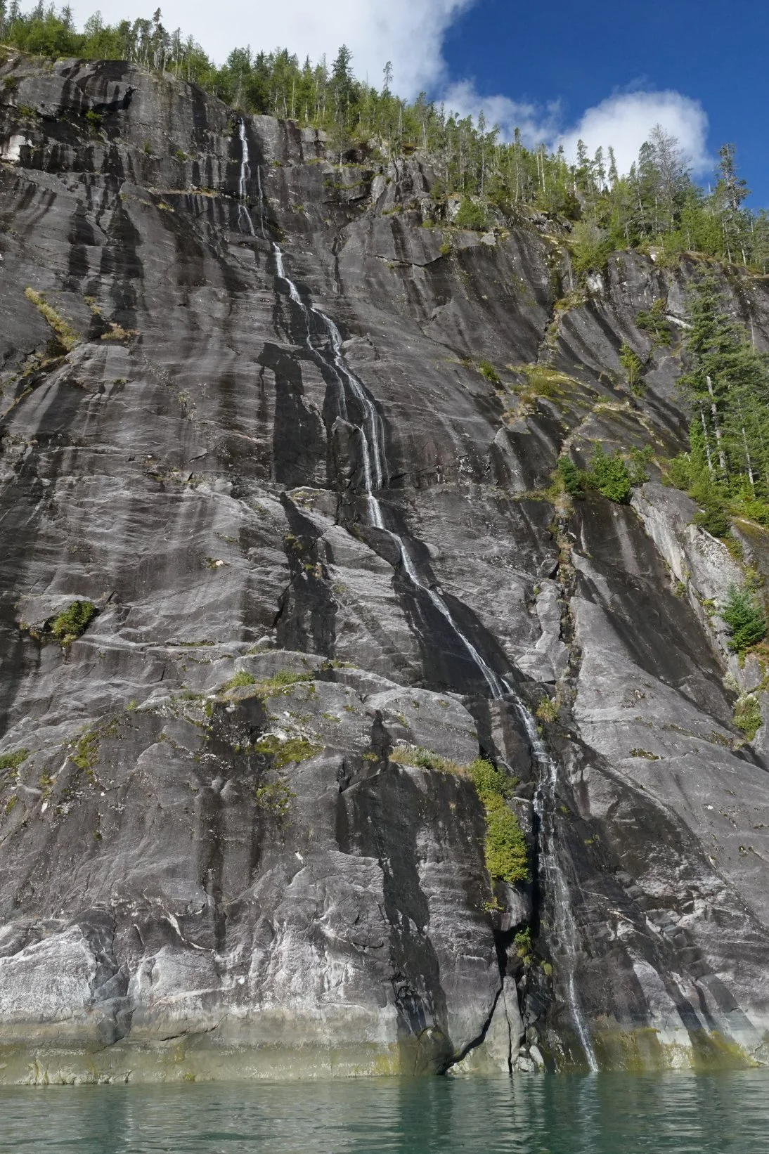
Waterfall down face of Alpha Bluff. I paddled over to the base of the waterfall to refill a three-day supply of drinking water, all without leaving the cockpit of my kayak.
Kayaking southbound down Bute Inlet toward Stuart Island. Even many miles from the head of the inlet, the water is still stained turquoise from the silt in the glacial runoff.
Pacific madrones on Fawn Bluff, Bute Inlet. In Canada, this species is most commonly known as the “arbutus,” after its genus name.
Pictograph, Orford Bay. Pacific Northwest indigenous rock art often depicts mythical creatures, of which this appears to be one.
The trip may have been a bit of a bust when it came to birds, but things in the mammal department looked much brighter. Altogether, I saw eleven species of mammal: mule deer (black-tailed subspecies), red squirrel (Vancouver Island side), Douglas squirrel (mainland side and in the Discovery Islands), eastern gray squirrel (during the drive through Washington), eastern cottontail (during the drive through Washington), harbor seal, Steller sea lion, humpback whale, Dall’s porpoise, mink, and of course, the brown bear.
The Dall’s porpoise was a particular treat. In recent decades, this species has been in decline in the inland waters, especially farther south in Washington where I do most of my paddling. The decline of the Dall’s porpoise has been offset by a boom in the numbers of harbor porpoises, to the point where I probably see at least a hundred harbor porpoises for every one Dall’s.
On this trip, however, every porpoise I saw—or at least every porpoise I could identify—was a Dall’s. I was sorry not to see any of my beloved little harbor porpoises, but it was worth missing them for once if it meant seeing so many of the rare Dall’s porpoises.
Harbor seal, Raza Island. During my transit up the eastern side of Raza, it seemed every headland I rounded concealed a fresh group of basking harbor seals, all of whom would belly-slide into the water as soon as my kayak hove into view.
Harbor seals at sunset, Francisco Island. This pair of seals was unusually frisky, chasing and splashing one another late into the evening and then again starting at dawn.
Dall’s porpoise, Nodales Channel. The Dall’s porpoise can be distinguished from the harbor porpoise by its overall larger size and darker coloration, its faster swimming, the gray coloration of the rear half of its dorsal fin, and the bright-white flanks.
Humpback whale fluke, Orford Bay. Offshore of Church House, a humpback surfaced unexpectedly so close in front of me that we nearly collided.
Western tent caterpillar, Orford Bay. Tent caterpillar numbers this year were far down from their peak during the 2023 outbreak, but they were still quite numerous in Bute Inlet.
Ochre sea stars, South Rendezvous Island. Not all sea star species have recovered since the great die-off of 2013, but the ochre sea star seems to be on an upward trajectory.
Green sea urchins, Raza Island. This is the smallest and easiest to handle of our three species of sea urchin.
Using the Rendezvous Islands as a base, I set off up Ramsay Arm to try for more brown bears. The Quantam River outlets into Ramsay Arm, and based on the river valley’s flat topology, I figured it was likely a salmon-spawning stream and therefore a possible foraging spot for bears.
Rainclouds rolled in while I was paddling up the arm. My faulty field-forecasting skills had failed to predict the onset of rain, so I had left my tent without a rainfly—and with my down sleeping bag exposed in the tent! A three-hour downpour ensued, but when I returned to camp that afternoon, the sleeping bag’s waterproof outer fabric had kept it dry, even as puddles of rainwater formed between the baffles of the sleeping pad. The sun came out, and everything was dry by bedtime.
It was low tide when I arrived at the Quantam River delta. As at the Orford River during low tide, a strong outflowing current prevented me from progressing very far upstream. I poked around on foot for a while but saw no bears.
Over the course of the next two days, I made my way back through the Discovery Islands toward Elk Bay. As during the outbound trip, my progress back was slowed by the need to coordinate the passage through the tidal rapids, in this case Surge Narrows and Okisollo Rapids. I passed the time waiting for Surge by strolling through the lovely provincial park at the south end of Maurelle Island. I passed the time waiting for Okisollo by lounging around Francisco Island, chatting with a kayaking couple from Courtenay, Chris and Joanne, and their young friend from Switzerland, Raph.
Rainclouds approaching up Ramsay Arm. It rained on only two of the eight days I was out.
Alex reading on South Rendezvous Island. The landing here was rough on barnacle- and seaweed-covered rocks, but the camping was sublime.
Derelict wooden boat, Surge Narrows Provincial Park. Antonio Point is connected to the rest of the park by way of a hiking trail through second-growth forest.
Kayaking Octopus Island at high tide. The Octopus Islands are the very soul of the Discovery Islands.
Hand-painted wooden boat signs in cabin, southernmost large Octopus Island. Over the decades, hundreds if not thousands of yachties have decorated this isolated cabin with driftwood signs bearing the names of their boats.
Granite Point, Quadra Island. Supposedly there are pictographs here, but once again I was unable to find any.
View of Kanish Bay from Discovery Passage. In every direction, at all times of day, beautiful sights stretch as far as the eye can see.
The brown bears may have been what lured me onto the water, but they weren’t what made the trip. As happy as I was to have found one of the famous bears of Bute Inlet, the trip would have been just as great without any bears. The point of sea kayaking is to immerse yourself in the wild environment for a few days—or a few weeks, if you can get them. Whether you see any particular sight or reach any particular goal is beside the point. The point is simply to be.
—Alex Sidles