My dad and I spent the better part of August one year completing a long-anticipated voyage into Gwaii Haanas, the national park that comprises the southern third of Haida Gwaii. Over the course of three weeks, we paddled down the east side of the park from the launch point at Moresby Camp to the small settlement at Rose Harbour, where we caught a zodiac back to the launch.
Route map. Paddle down, zodiac back to our car at Moresby Camp.
Gwaii Haanas was completely spectacular, easily one of the top five kayaking grounds on the west coast. Thanks to our north-to-south route, the trip started out beautiful and only grew more so as we headed farther into the park, farther away from modern civilization.
Skeena River, Prince Rupert. We slept out on this rock near Skeena River. Due to wildfires closing several highways, we took three days to drive up to Moresby Island, passing through Prince Rupert and across Hecate Strait by ferry.
Cumshewa Inlet from Louisa Island. High pressure aloft gave clear, hot skies during the first week.
Black turnstones winter in Cumshewa Inlet. By the end of August, many winter species were beginning to arrive.
Hecate Strait southbound toward Skedans Islands. We typically travelled less than ten miles a day, so there was time to enjoy everything.
We ended the trip with seventy-two species of bird and twelve species of mammal. Humpbacks were the only whale we saw, but we got at least one very good view of one during the zodiac ride home. Most other humpbacks we experienced only as distant spouts.
The best bird experience was on an unnamed rocky islet just southeast of tiny Rocky Islet in the Copper Islands chain. In the middle of the night, we began to hear a loud chittering sound. We stuck our heads out the tent and shined flashlights, revealing hundreds of dark shapes whipping back and forth in the dark, misty gusts. We thought at first they were bats, but I eventually attracted one to hover in front of my flashlight beam and saw it was a fork-tailed storm-petrel. Later, biologists at the Haida Heritage Centre listened to a recording dad made of the calls and told us that there were also Leach’s storm-petrels as well.
Hundreds of birds kept up the chorus all night long during both nights we were on the islands. They only stopped shortly before dawn. Sometimes, they flew so close to the tent we could hear the flap of their wings.
Haida watchwoman Deedee Crosby describes life at Kuna. Deedee’s own grandmother lived at Kuna in the 19th century, and Deedee told us lovely stories of life in the ancient village.
Trees grow naturally from old poles. Decay is a natural and welcome part of a totem’s lifecycle, not something to be resisted.

Fluted column reflects European influence. The arrival of whites in Hadia Gwaii brought new tools and new ideas to the islands, influencing both the size and design of Haida poles.
Despite a decent species count for this trip, Haida Gwaii struck me as a bit of a bird desert. Many species that would be common on the mainland were absent from the islands or present only in small numbers. The alcids were diverse and abundant—we saw the Big Four, plus Cassin’s auklet, plus both puffins—but on balance, southeast Alaska had more birds, and the Broughtons had more mammals. Wildlife here was good but not outstanding when compared with other hotspots along the coast.
What Haida Gwaii had that no other region can compete with is the richness of the human culture. There were more old villages and campsites here than any other place I’d seen, and the level of preservation was absolutely astonishing.
Walking through the ancient villages with the always-knowledgeable Haida watchmen was more than merely an educational episode; it was an emotional experience. The inhabitants of the villages departed long ago, but they left behind beautiful physical monuments of their existence that still stand, as well as a library of memories and culture that still exist in the minds of the Haida today.
Limestone Islands, high-pressure ridge aloft. We didn’t use a guidebook to find campsites. We just guessed from the chart where good ones might be, then hunted around till we found one.
Crossing Laskeek Bay in morning calm. The sheltered east side of Gwaii Haanas is accessible to paddlers of all skill levels.
Endangered northern abalone. River otters left trails of mussel, crab, and abalone shells all over the beaches and forests.
Longhouse remains at Tanu. Tanu was once home to dozens of longhouses and hundreds of people.
There were many clearcuts visible in Haida Gwaii, especially outside the park. The more modern ones presented merely the usual, galling spectacle of a few dozen acres hacked out in polygons from the forest. The older ones, though, were the worst I’ve ever seen, even worse than Mt. Paxton and other famously devastated sites. Some of the mountains looked like god had come through with a lawnmower, flattening every tree in his path. As bad as clearcutting is today, it was worse prior to the 1980s.
But these same terrible cuts served as the inspiration for the park. Haida activists blockaded the timber harvest on Lyell Island, kicking off a legal and political battle that culminated in the creation of Gwaii Haanas. The Haida built a kind of temple to this struggle at Windy Bay, the last unimpacted salmon stream on Lyell Island. The pole and old-growth nature walk at Windy Bay were tributes to the victory of environmental and cultural values over greed.
Dad and I also met our first marbled murrelets of the trip at Windy Bay. How apt that an old-growth-dependent species would be present at the site where the old growth was saved.
Don’t skip Windy Bay just because it isn’t an ancient village site. (In fact, Windy Bay is an ancient village site, though the ruins are faint and not advertised in park literature.) The cultural life of Haida Gwaii owes just as much to the actions of the Windy Bay protestors as the people of the long-ago villages. It took both the moderns and the ancients to make these islands the magical place we experience today. Windy Bay is an emotive reminder of that continuity. It’s as inspiring as the old sites.
Modern commemorative totem at Windy Bay. The human figures on the totem represent the activists, arms linked to prevent the passage of logging trucks.
Kayaking around Agglomeration Island, looking for campsite. Whenever possible, we tried to camp on small, offshore islands to avoid the pervasive bugs.
Beautiful camp by Ramsay Island stream. We brought only six gallons of water for two people, so we sometimes camped near streams to fill up.
The beach at Ramsay Island. Camping in Haida Gwaii is much easier than along the mainland coast across Hecate Strait.
Ramsay Island sunset. We tended to stay up late and sleep in. There was never any hurry.
The most beautiful part of the park was Juan Perez Sound, the body of water south of the wonderful hot springs on Gandil Kin Island. The sound was surrounded by high, jagged mountains that trapped the passing fog. A blanket of gray settled over everything, but each gray had a slightly different shade and character than all the others. Everything was still and quiet, and you felt as if you were the first human being in the world to see this place.
Hottest part of Gandil Kin Island hot springs. No one else was at the hot springs the day we visited, so we spent three hours soaking in the hottest pool. When I put my ears underwater, the bubbling of the springs sounded like the Earth’s stomach growling.
A 22-degree halo protends rain in 24–48 hours. Wx radio reaches all parts of Haida Gwaii, but it’s still fun to make your own predictions, using evidence like this 22-degree halo to time the arrival of rain.
Crossing windy Juan Perez Sound. Once the high-pressure ridge aloft collapsed, a train of surface lows began striking the islands, a new one every day or so.
A tombolo campsite at Wanderer Island. Not once did we share a campsite with anyone else. The only people we encountered were at the watchman sites and Rose Harbour.
Pigeon Guillemot in Burnaby Narrows. The Big Four alcids is what I call pigeon guillemot, common murre, marbled murrelet, and rhinoceros auklet. You can expect to see these on any trip. On Haida Gwaii, you can also expect tufted and horned puffins, Cassin’s auklets, and ancient murrelets.
Once the low-pressure systems began to hit, we started taking weather days. We had originally budgeted twenty-four days to make it all the way south, visit Sgang Gwaay, and paddle back to Rose Harbour for pickup. In the event, that itinerary took us only eighteen days, and that was with at least four weather days, plus a full day at the hot springs, plus stopping at each watchman site for several hours at least—all while generally paddling under ten miles per day on travel days.
Skincuttle Inlet south of narrows. Trees, rocks, clouds: the stark and beautiful face of the Pacific Northwest.
West of the Copper Islands storm-petrel nest site. Some of the Copper Islands were closed to protect nesting seabirds, but we encountered nesting seabirds outside the closure zone, as well.
Goodwin Point rock garden. Tidal currents were a non-factor until south of Skincuttle Inlet, at which point it became important to consider them. Wind was a factor in all inlets, even on calm days, due to gap winds and heating-induced sea breezes.
A tarp palace at Louscombe Point. Introduced deer grazed down the undergrowth so badly that campsites were easy to find everywhere.
The highlight of trip was the ancient village of Sgang Gwaay. As had been our fortune at most of the other watchman sites, dad and I had this one to ourselves. I was lucky to spend a half-hour or so alone in the village while dad went to summon the watchmen. Walking by myself among the silent, lonely poles, I thought about the civilization whose busy lives had once played out here. Today, the entire site is quiet and still, more like a glade in a forest than a place that people built.
I thought about what our own civilization will leave behind and even what I myself will leave. The totem poles are the most obvious remnant of the ancient villagers, but when the two young watchwomen arrived to talk to us, I saw that their knowledge of the village site, their appreciation of their culture, and their overall approach to life were just as much the legacy of the long-gone villagers as the totem poles were, even if the watchwomen never met the villagers, and even if they live very differently than the villagers once did. Even without setting adze to wood, we will all leave behind a legacy in humanity that endures long after us.
Rainforest trail on Anthony Island. The rainforest leading to Sgang Gwaay was as beautiful as the village itself.
Mortuary poles of Sgang Gwaay. The only sounds here were birdsong and the faint wash of waves upon the beach.
Ancient village of Sgang Gwaay. The poles are monuments to centuries of human activity, generation after generation.
Bear motif mortuary pole. The poles that remain at Sgang Gwaay are mostly mortuary poles. The remains of the honored dead were placed in a box on top.
Killer whale motif. Natural and supernatural animals are equally prevalent in the motifs.
Family crests that are still in use today. Some of the knowledge of the lineages and stories represented here has been lost, but an enormous body of knowledge remains.
Pole undergoing natural decay. There is an overwhelming impression of humanity in these ancient poles, as if the carvers were whispering in our ear even now.
The eyes almost seem to see. The arrival of iron and steel tools in the late 18th century sparked an explosion in the size and complexity of the carvings.
Even decayed poles have a fierce aspect. When the village was inhabited, there were no trees. The forest that seems so timeless is actually quite recent, at least as forests go.
Although we were the only visitors that day, the women at Sgang Gwaay had recently been talking to a tour group that was interested in birds as well as history. From them, they had learned that a horned puffin had been spotted on some rocks near Anthony Island, mixed in with a large colony of tufted puffins.
Dad and I set out to find the puffins, and they were right where the watchwomen reported them.
Tufted puffin at Adam Rock, Gwaii Haanas. Tufted puffins are my favorite alcid. They have so much personality and style.
Tufted puffin flock resting Adam Rock. There were at least a hundred tufted puffins at Adam Rocks.
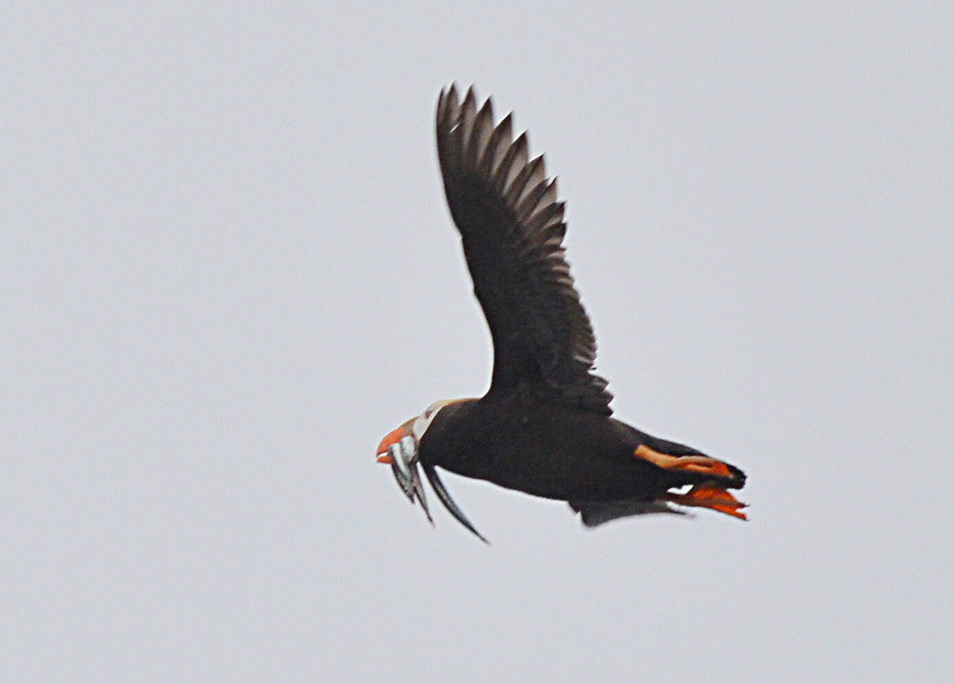
Tufted puffin carrying fish at Adam Rock. Their large beaks allow parents to carry multiple fish back to the nest in a single trip, saving energy.
Horned puffin at Flatrock Island. We did not find the horned puffin at Adam Rocks, but I did find two pairs of horned puffins at Flatrock Island, thanks to a tip from a resident of Rose Harbour.
After the transcendental experience of Sgang Gwaay and the fabulous puffin colonies, dad and I agreed that nothing ahead of us was going to surpass what we had already seen. We decided to end the trip on the highest note, so we put in at Rose Harbour, where the kindly people at the guest home allowed us to call our zodiac in for an early pickup. Back at Skidegate, we managed to slip aboard an overnight ferry as standby passengers, and with a heroic twenty-hour driving effort, we surprised our wives by getting home five days ahead of schedule.
Departing Louscombe Point in heavy fog. Even on days that ultimately turned sunny, the morning fog was often so heavy that we lost sight of land during long crossings.
Partial solar eclipse. One of the Rose Harbour residents alerted us that the partial eclipse was just barely visible through the mist.
Dad’s favorite sitting rock near Rose Island. While we waited for our zodiac, we set up camp across from Ross Island. I went down to find more puffins while dad stayed on the beach and read.
Sunrise over Houston Stewart Channel. Houston Stewart Channel near Rose Harbour is uncommonly beautiful, but it is essential to pass with the tidal currents instead of against. Strong gap winds also funnel through here.
The wildlife and natural splendor of Haida Gwaii were excellent, as I hope the photographs show. But the real treasure of this place was the people. The ancient ones left us their wonderful villages and artifacts, and the living ones shared their knowledge and their kindness with uncommon warmth and openness. Unbeknownst to them, the people of Haida Gwaii have created yet another legacy in my own heart.
—Alex Sidles