It had been a decade since my last trip to Clark Island in the San Juans, and I was eager for a return visit. I also wanted to revisit the petroglyph boulder on nearby Lummi Island. I decided to combine the two adventures into one: a circumnavigation around Lummi Island, with an overnight on Clark Island.
Route map. Beach access at Gooseberry Point on the Lummi Indian Reservation is closed to the public absent permission, although permission is usually freely given if asked.
The tide floods northward up both sides of Lummi Island and ebbs southward. From Gooseberry Point, I rode the tail end of the flood up to the northern tip of Lummi Island and then rode the building ebb down to Clark Island.
Before heading across to Clark, I poked along the northwestern shoreline of Lummi Island, looking for the petroglyph boulder. Even though I remembered its location to within a few dozen meters from a previous trip, I was unable to relocate it.
The problem was the tide. Like most petroglyph boulders in the Pacific Northwest, the Lummi Island petrglyph is situated below the high-tide line. My arrival at the northern end of Lummi Island coincided with the turn to ebb, so the tide was near its maximum height. The petroglyph boulder was either completely submerged or else its face was awash such that I could not recognize it.
Launch at Lummi Indian Nation dock, Lummi Island in distance. The only boat traffic this morning was the crossing back and forth of the Lummi Island ferry.
Kayaking northward up Hale Passage. Lummi Island to the left, Point Whitehorn to the right.
Rounding Point Migley, northern tip of Lummi Island. A reef extending northward from the point caused breakers at least a hundred meters offshore.
Kayaking across Rosario Strait toward Clark Island. Orcas Island looms large in the background behind Clark.
Arriving at Clark Island. Most of the campsites, and all of the most easily accessible ones, are here along the eastern shore.
Thanks to the well-timed assistance of the tides, I arrived on Clark Island shortly after ten o’clock in the morning on Saturday. There was no point departing the island before eleven o’clock in the morning on Sunday, again because of the tides, so that meant a full twenty-four hours to explore the island.
Signs of spring were popping up in earnest. Some of the earliest berry shrubs had started to blossom. The deciduous trees had just started leafing out. Violet-green swallows were swooping over the beaches at the south end of the island. Song sparrows and fox sparrows were singing everywhere in the forest.
A couple off a powerboat paddled ashore in sit-on-tops, but they returned to their mothership and motored away late in the afternoon. A sailboat moored overnight but did not come ashore. I was the only person on the island overnight.
Alex in camp, Clark Island. The most convenient campsites are along the eastern shore, but the campsites with the best views are on the south end.
Western shore, Clark Island. Sandy beaches are a rarity in the San Juans.
View from south campsite, Clark Island. Scenes like this are characteristic of the San Juan Islands.
Lodgepole pine, also known as shore pine, south end of Clark Island. This is our most common native pine species at sea level.
Blossoms of red-flowering currant, Clark Island. According to Pojar and MacKinnon’s Plants of the Pacific Northwest Coast, the blossoms of this species are “harbingers of spring and hummingbirds.”
The bird species here in late March were a mix of lingering, overwintering birds and early springtime arrivals. The violet-green swallows on Clark Island must have just arrived. They were the first violet-greens I’d seen this year.
Meanwhile, on the water in the northern half of Hale Passage, there were dozens of overwintering long-tailed ducks that had not yet departed for the arctic. The red-necked grebes had all transitioned to their breeding plumage, but the horned grebes had only just begun their transition. Half of the common loons had transitioned, but half were still in their non-breeding plumage.
Red-necked grebe, Hale Passage. This is the shyest and least approachable of our grebe species.
Common loon, Hale Passage. I love the elaborate stripes and checkers on the neck, nape, breast, and back.
Surf scoters, Hale Passage. Most surf scoters will migrate to the arctic to breed, but a few will remain on our waters year-round.
Bufflehead, Hale Passage. This species is our classic near-shore sea duck.
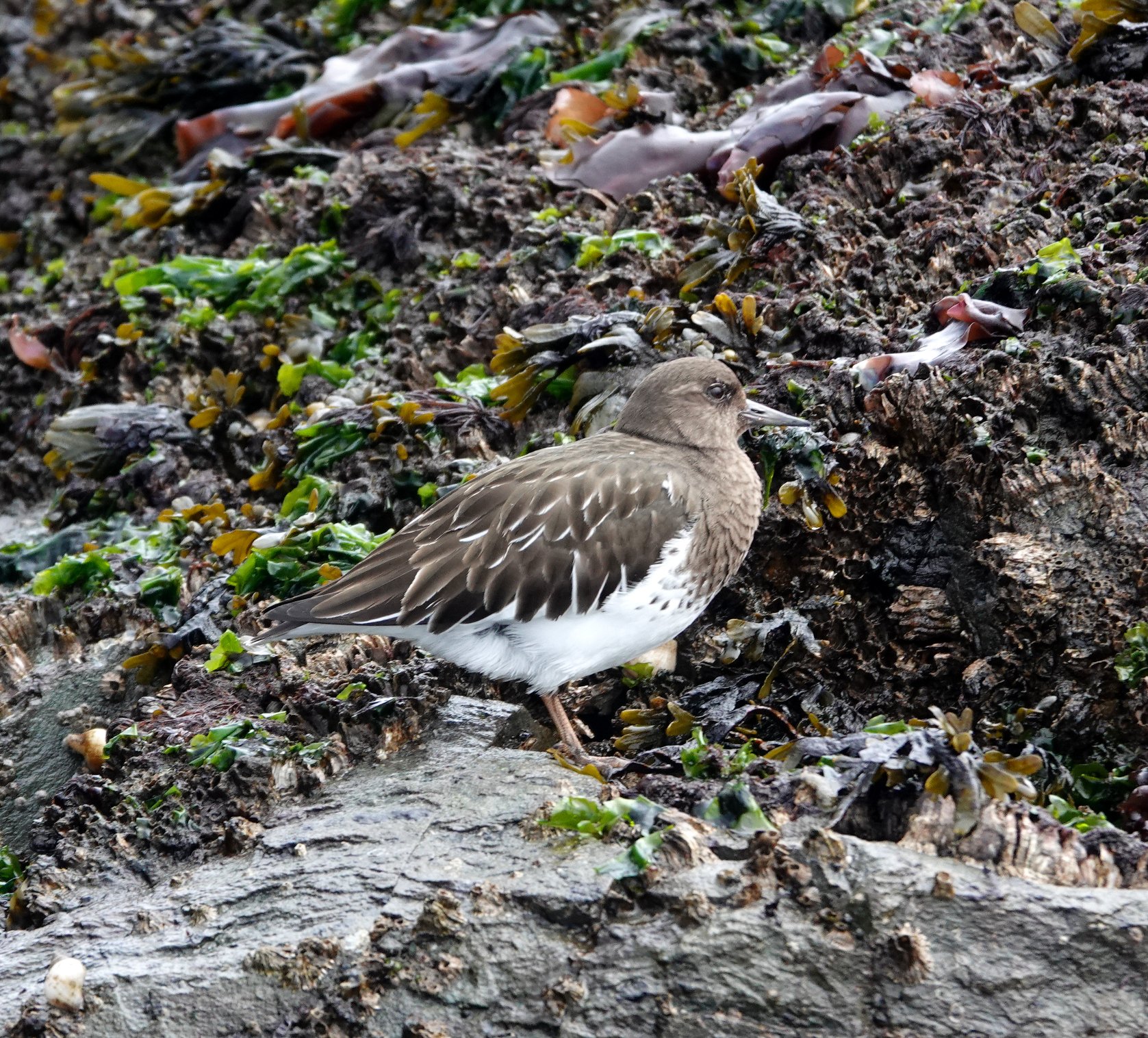
Black turnstone, Lummi Rocks. Half a dozen turnstones and a lone spotted sandpiper were the only shorebirds I saw, so it appears the spring shorebird migration has not yet begun.
Song sparrow, Clark Island. Unusually, the fox sparrows were singing louder and in greater numbers than the song sparrows were.
On my way south from Clark Island, I stopped for a lunch break on Lummi Rocks. This small, offshore island is part of the Bureau of Land Management’s holdings in the San Juans. In 2013, President Obama declared the San Juan Islands National Monument over the BLM islands. The national monument declaration eventually spurred BLM to develop a resource management plan for the islands, an action BLM could have taken decades earlier on its own initiative but never had.
The 2023 RMP closed Lummi Rocks and most of BLM’s other offshore islands not only to camping but also to day-use. Having previously camped on Lummi Rocks in 2018, I was crushed by the closure. Lummi Rocks was a great campsite, and there aren’t any others nearby.
On today’s trip, I swung by Lummi Rocks to see what the current state of affairs might be. To my surprise, the same old sign I’d seen on Lummi Rocks back in 2018 was still there. The sign did not say “no entry” or even “no camping.” Instead, it said the island was an area of “fragile habitat” and asked visitors to “respect the ecology.” It did not order visitors to keep out.
Even so, the rule in the RMP is clear: neither day-use nor camping are allowed. Lummi Rocks is named on page 29 of the RMP among the offshore islands on which “BLM will allow public access only for authorized scientific, educational, and cultural uses.” The sign on the island, which is silent as to entry, cannot overrule the unambiguous prohibition on entry set forth in the RMP.
The public could be forgiven for not knowing of the prohibition. Rather than post the prohibition on a sign so people could read it upon arrival, BLM simply left up the same old sign from before the prohibition. Nor could the public learn of the prohibition by reading page 29 of the RMP, as I did years ago, because BLM no longer makes the RMP available anywhere online—this despite the fact that producing the RMP took years of work by an army of government officials, paid consultants, and members of the public. BLM’s 2024 manager’s report for the San Juans uses a photo of Lummi Rocks as its cover photo, so I know they have been out to the island since the prohibition was adopted, but apparently they were too busy taking pictures to update the sign during their 2024 visit. After 2024, there are no manager’s reports at all on their website.
The sustained sloppiness on the part of BLM is enough to make one question just how effectively these “resources” are being “managed.” Why should any member of the public care more about BLM’s rules than BLM itself apparently does?
The ebb carried me southward from Lummi Rocks to Carter Point, the southernmost tip of Lummi Island. From here, I must work my way northward up Hale Passage, but the ebb was still setting southward. I pulled off onto one of the many pocket beaches at Carter Point to wait an hour for the current to turn. The favorable flood then carried me the seven miles (11 km) back to my car in just an hour and a half.
Rounding Carter Point. On the east side of Lummi Island—to the right in this photo—the water was stained brown by outflow from the Nooksack River.
Ochre sea star, Carter Point. The sea stars were only visible during the lowest part of the tide.
Kayaking north up Hale Passage. From left to right: Lummi Island, Portage Island, Bellingham Bay.
Despite my frustration about the closure of Lummi Rocks, and despite not relocating the petroglyph on Lummi Island, I was still happy to have made it back to Clark Island after all these years. A weekend spent on one of our lovely state park island is the best way to welcome the arrival of spring.
—Alex Sidles