It had been an uncommonly mild winter in the Pacific Northwest. Temperatures stayed warm, skies stayed clear, winds stayed soft.
The forecast called for a window of particularly calm weather to coincide with the three-day weekend for Martin Luther King, Jr. Day. I headed up to Desolation Sound to circumnavigate East Redonda Island.
Route map. From Seattle, the outbound drive took about twelve hours, the return ten hours.
Fog piled up in the basin of Desolation Sound each morning. It was so thick not even direct sunlight could drive it away. The sun’s only effect was to cast a low, white arc in the sky ahead of me—a fogbow.
In the midst of the bright fog, pieces of driftwood floating on the water nearby seemed to be hovering in the air somewhere far away. This and other illusions threw my mind into doubts of one kind and another.
The famous mountains of Desolation Sound were completely concealed. I was reminded of a verse from the haibun of Matsuo Bashō, the seventeenth-century Japanese poet:
In a way
It was fun
Not to see Mount Fuji
In foggy rain.
The only thing I could see clearly was the bow of my kayak, with its built-in compass. The sun was shining through the fog from the south, and my course happened to be a northerly one. As an experiment, I practiced calculating the time, using the bow compass and the shadow of my own head to form a sundial. My results were never more precise than half an hour to one side or the other of the true time, but that’s good enough for a lot of purposes.
Launch at Okeover Arm Provincial Park. Half a dozen sailboats were anchored in the inlet, their owners perhaps waiting for the fog to lift or perhaps waiting even longer for something else to happen.
Fogbow, Desolation Sound. The end of the fogbow is only ever a few hundred meters away, but as with the rainbow, it is impossible to reach the end no matter how fast you paddle.
Kayaking across foggy Desolation Sound. Conditions like this are a reminder that the ocean and the atmosphere are really just different expressions of the same underlying idea.
Arboreal eclipse, East Redonda Island. Were it not for the passage of these trees’ silhouettes in front of the solar disc, there would be no way to know there was an island anywhere in the vicinity.
The hot sun and the wet fog struggled for hours over which would dictate the consistency of the air. The air played a neutral party in the struggle, supplying no breath of wind that might have moved the contest one way or the other.
Nothing beats the sun for sheer strength. It finally prevailed over the fog early in the afternoon. The fog retreated to the lowest, darkest valleys in the mountains. As if to honor the sun's success, the sky unfurled its richest blues. Finally, I felt as though I could understand my surroundings.
Beaten but not defeated, the fog bided its time in the mountain valleys, waiting for nightfall. As soon as the weary sun set, the fog surged forth and once again spread itself everywhere.
View down Waddington Channel. This species of fog is radiation fog, formed during clear, still nights when the air temperature drops to the dew point due to the earth’s radiating its stored heat into space.
Kayaking past Marylebone Point, West Redonda Island. The fog began to lift just as I reached the southeastern tip of West Redonda Island.
View of Horace Head, Unwin Range in background. The fog bank was only a few hundred feet deep in its vertical extent but miles wide in its horizontal extent, so it was easier to see distant objects high in the sky than nearby objects low on the water.
One of my purposes in circumnavigating East Redonda Island was to look for ancient indigenous pictographs: paintings on rock surfaces, preserved across centuries by a chemical bond between the underlying rock and the red, ferric ochre pigment. From Doris Lundy’s famous master’s thesis of 1974, I identified four pictograph sites along my route: Durham Point and Booker Point on East Redonda Island, Walsh Cove on West Redonda Island, and “the first point north of Foster Point near Forbes Bay” in Homfray Channel on the mainland.
Durham Point was the first pictograph site on my route. There were plenty of likely-looking rock surfaces, but I didn’t find any pictographs here. I was disappointed but not discouraged. Failure is more common than success when it comes to hunting for rock art. In 2025, I searched ten sites in the Discovery Islands and Bute Inlet and only found a pictograph at one.
Walsh Cove was the second pictograph site on my route. It was also my campsite for the first night. The January days were so short there wasn’t enough time to search for pictographs when I pulled up in the late afternoon. There was just enough time before sunset to haul the boat out of the water onto the rocky shelves, make dinner and tea, and set up camp. Pictographs would have to wait until the morning.
Kayaking past Durham Point, East Redonda Island. Mine was the only boat in the channel between East and West Redonda Islands.
Walter Point, East Redonda Island. The landscape of Desolation Sound strikes nearly a perfect balance in its proportions of waterways and mountains.
Approaching Walsh Cove. Walsh Cove is more welcoming as an anchorage for yachties than a campground for kayakers.
View of Dean Point, gap between West Redonda Island (left) and East Redonda Island (right). Even though the gap is narrow, the tidal currents through the gap are always weak.
The Walsh Cove pictographs were at the head of the cove, on a tall, wide wall of pale, granitic rock. After the sun came up, I spent an hour exploring the wall, both on foot and by boat. I kept finding new pictographs the entire time, from the moment I arrived until the moment I left. Undoubtedly, there must have been even more than the ones I discovered.
Some of the Walsh Cove pictographs were clustered in panels. Other pictographs stood alone. Some of the pictographs were on prominent rock faces. Others were hidden away in the woods. Some of the rock faces were covered in multiple figures, while other, nearby rock faces, seemingly equally suitable, remained bare. The closer I tried to follow the reasoning of the ancient artists, the less I was able to understand.
Pictograph panel, Walsh Cove. The “forked stick” at the top of this panel is a common motif among Coast Salish pictographs, though its meaning is obscure.
Head-and-shoulders portrait, Walsh Cove. The left half of this pictograph has weathered away to a considerable extent.
Pictograph panel, Walsh Cove. This is one of the most prominent panels but also the hardest to interpret.
Dolphin or fish figures, Walsh Cove. These figures were the most identifiable among a panel of lines, branches, and curves.
After the late-morning tour of the pictographs, it was back to the fog again for the next five hours. Once again, my navigation was reduced to following a bearing on the compass or an arrow on the GPS, or else handrailing the shoreline.
Though there were no other people to be seen, I was never alone. In the distance, through the fog, I could hear the constant noise of industry: the droning of electric generators at fish farms, the chugging of tugboats pushing barges or towing log booms, and the occasional, deep thud of an ammonium nitrate explosion, which could have been associated with mining or else the blasting of new logging roads.
It was amazing people could come to a place like Desolation Sound and not think of anything better to do than chop it down, blow it up, and dump farm waste into it. Even more confounding, these vandals were all being paid. I was the only one losing money. How foolish I must have seemed, if anyone had noticed me slipping silently through the fog.
Harbor seal, Walsh Cove. Besides the harbor seal, the other mammal species I saw were the California sea lion, Dall’s porpoise, and harbor porpoise, plus a herd of deer on East Redonda Island and a lone Douglas squirrel at Okeover Arm.
Handrailing mainland shoreline near Homfray Creek. Small waterfalls ran endlessly down the cliffs to meet the sea.
View of Foster Point in fog. Tidal currents are negligible in most parts of Desolation Sound, so a kayaker is free to travel in any direction at any time.
View across Homfray Channel from East Redonda Island. I’m not convinced this view could have been improved even if the skies had been clearer.
Horned grebe, Waddington Channel. Bashō again: “How amusing at first / How melancholy it was later / To see a cormorant show / On the darkening river.”
I failed to find another pictograph site at Booker Point, but I did find the site at the unnamed point north of Foster Point. It was a lucky find, because I had forgotten to bring my page of notes where the sites were all listed. Instead, I had to rely on my dim memory of where the sites were supposed to be. “Foster Point” on my map did ring a bell, but it wasn’t until the first panel of pictographs leaped off a cliff that I was certain I had remembered it correctly.
Most of the pictographs at the unnamed site north of Foster Point were arrayed in two panels about thirty meters apart. The northern panel was especially striking, consisting of two dozen or so individual figures, many of them legible even across the gulf of centuries and culture separating my mind from those of the artists.
Northern pictograph panel, unnamed point north of Foster Point, Homfray Channel. The ancient pictograph artists were careful to choose locations protected by overhangs, although a certain amount of mineral-rich runoff is actually desirable to aid in the bonding of the pigment and the rock.
Anthropomorph, northern pictograph panel. This figure’s head and one of its arms have been defaced by gunshots.
Canoe with two occupants, northern pictograph panel. It’s always risky to interpret pictographs, but the figure in the bow of the canoe (right) seems to me to be poised to thrust a harpoon.
Geometric figure, Homfray Channel pictograph. This figure, whose shape resembles that of an inverted “copper,” stood apart from either of the two main panels.
Pair of fish or cetacean figures, southern pictograph panel, Homfray Channel. These figures are unusually large by the standards of pictographs.
School of five fish or cetacean figures, southern pictograph panel. Schools of aquatic animals appear on several of the panels at Walsh Cove and Homfray Channel, although each school never numbers more than five members.
Late in the afternoon of the second day, I finally glimpsed some of the mountains that are one of the chief attractions of Desolation Sound. Despite the mildness of the winter, the peaks were crowned with snow. It was satisfying to reflect that later on, in the dryness of summer, this would be the very snow whose melting would keep the creeks flowing.
I camped the second night in the Curme Islands. I chose West Curme Island, as I always seem to whenever I pass this way, for the ease of landing—although “easy” is not the right term to describe any landing in the rocky Curmes. Once again, owing to the shortness of the winter days, it was a scramble to get the camp set up and the dinner and tea made before nightfall. Stars and satellites appeared overhead before I was finished.
A constant patter of raindrops fell on my tent all night. It wasn’t really raindrops. It was condensation dripping from the needles of lodgepole pines.
Booker Point, East Redonda Island. Somewhere among these cliffs is another pictograph site, but I could not find it today.
Mountains over Mary Islands. Desolation Sound is one of those places, common along the inland waters, where the best views of the sunset are found by facing away from the setting sun.
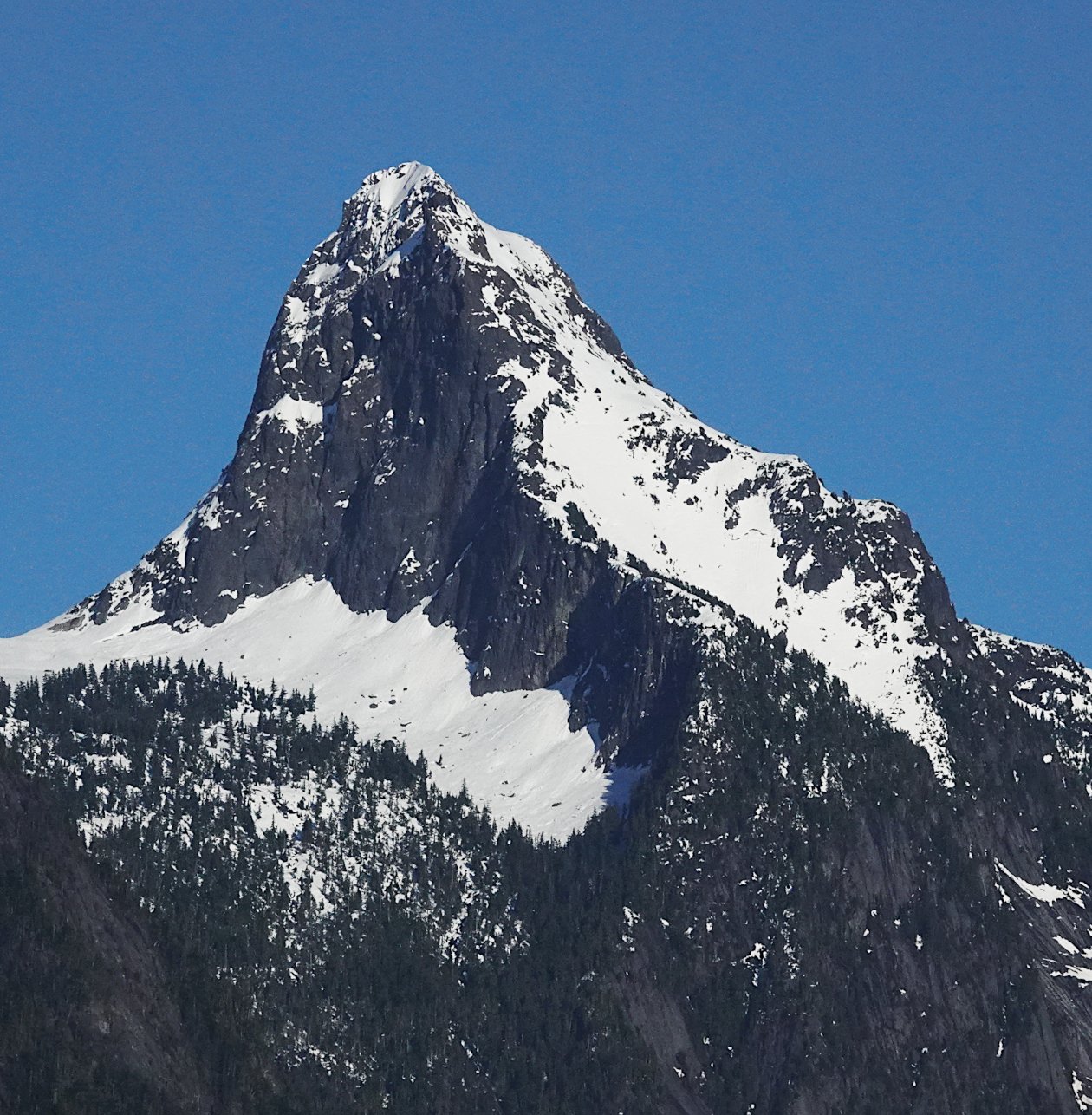
Mount Denman, Desolation Sound. This 6,500-foot (2,000 m) peak is popular among climbers from Powell River.
Edith Island, Okeover Inlet. The morning fog lifted just as I arrived back at the launch beach.
It’s tempting to think the trip would have been improved if certain things had been different: for example, if I had been able to find the two pictograph sites that I missed, or if the mountains had been visible earlier or for longer periods of time, or if there hadn’t been so much industrial activity.
Such thinking misses the point. The specific things we encounter or don’t encounter on a trip are only shadows of another, deeper reality. We don’t actually need them, although they’re pleasant to look at. There’s even some risk of confusing the thing for the form. A missing pictograph, an impenetrable fog bank, and even a wilderness beset by looters all serve to illustrate certain truths just as clearly as if there had been a dazzling pictograph, a bright sky, and an empty wilderness.
—Alex Sidles