In 2018, I kayaked to Smith Island, the most remote island in Washington, to look for seabirds at their nesting colony. In 2022, I kayaked to Triangle Island, the most remote island in British Columbia, again because of the seabirds. This year, the seabirds called me once more, this time to the most remote island in southeast Alaska: Forrester Island, in the mouth of Dixon Entrance.
Forrester Island is at least sixteen miles (25 km) seaward of its nearest neighbor, Dall Island—itself a remote, inaccessible, uninhabited island. Seabirds love nesting in such desolate places. Forrester Island, in conjunction with its outlying sisters of Lowrie and Petrel Islands, is a member of the “millionaire’s club:” a seabird colony that is home to over one million nesting birds.
Reaching Forrester Island by kayak was no small production. As long as I was traveling such a long distance, I might as well throw in a circumnavigation of nearby Dall Island to look for archaeological sites: pictographs, petroglyphs, and village sites with house pits and totem poles. Having added Dall Island to the itinerary, it only made sense to add Baker and Suemez Islands for their remote, sandy beaches.
I launched from the small town of Craig on Prince of Wales Island for a seventeen-day trip. It was my first time back in Alaska since 2014.
Route map. From Seattle, my dad drove me to Bellingham, where I walked onto the Alaska Marine Highway ferry, rolling my kayak on a cart, sailed aboard the ferry for thirty-eight hours to Ketchikan, walked onto the inter-island ferry from Ketchikan to Hollis on Prince of Wales Island, and finally hired a friend to drive me and the kayak thirty miles (48 km) across Prince of Wales Island to the launch point at Craig.
This southernmost corner of southeast Alaska is known for its geology. Most of the offshore islands here are composed, in large part, of limestone karst. Jagged cliffs spike into the sky. Steep valleys plunge toward the sea. Groundwater seepage excavates large, deep caves, some of which I was able to enter and explore.
Southeast Alaska is also known for its weather. The sky was usually cloudy and often drizzly. It rained at least part of the day on each of the first eleven days, including one stretch when it rained continuously for twenty-four hours due to the approach of a low-pressure cyclone. The rain finally disappeared when a steady ridge of high pressure moved in offshore, but the high pressure also created a significant sea breeze effect, in which northwesterly winds blew down the channels at speeds up to twenty knots all afternoon and into the evening.
The combination of craggy landscapes and clinging stratus clouds often produced striking landscapes. Some people might have wished for blue skies and hot sun, but I was content with the cool and the gray.
Kayaking Ursua Channel toward Baker Island. Passing fishermen often seemed surprised to meet a kayaker in these waters.
Kayaking Siketi Sound, Noyes Island in the distance. Each time I crossed a fresh horizon, another, even more beautiful horizon would appear beyond.
Karst shoreline of Baker Island. There were enough beaches on the larger islands that finding a campsite was never a problem.
Karst slopes of Baker Island. The sharply eroded slopes of Baker and Dall Islands reminded me of Kauai, if Kauai were thirty-five degrees latitude farther north and twenty-five degrees Fahrenheit (14 °C) colder.
Arcada Rock, Baker Island. Arcada Rock and nearby Outer Point were home to more horned puffins than any other place I visited on this trip, even the much more remote Forrester Island.
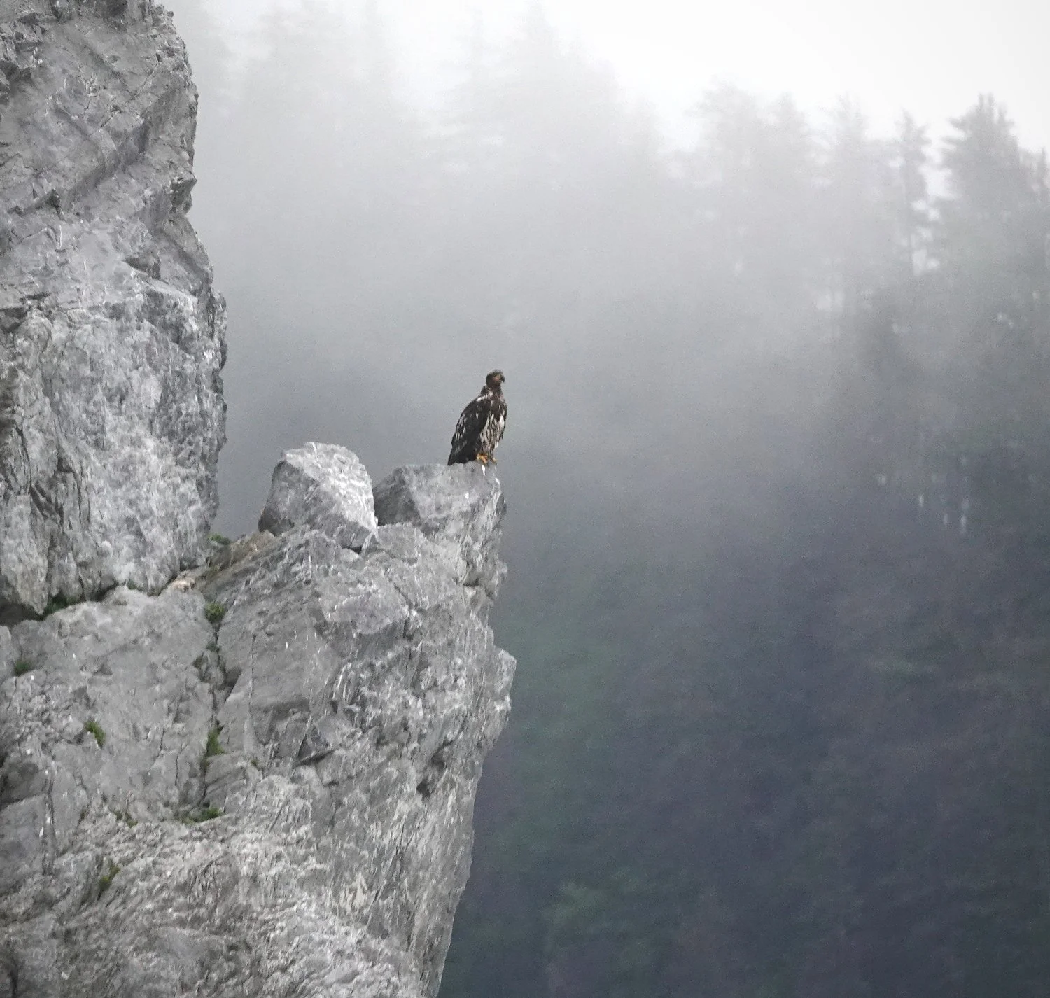
Bald eagle at Arcada Rock. Eagles were the only raptors I saw in Alaska.
Alex on Baker Island. Most of the beaches on Dall Island are gravel or cobble, but Baker and Suemez Islands have a few large, sandy beaches.
Seventeen days was more than enough time for the trip. I took five full days off from paddling, either to rest, shelter from adverse weather, or explore for archaeological sites. Of the twelve days I did paddle, four days were short, involving under ten miles (16 km) of paddling each day.
The slow pace was dictated, in part, by the ferry schedule. The ferry from Ketchikan to Bellingham only runs once a week, so there was nothing to be gained by finishing the kayaking early.
Only eight days involved significant mileage. Two of those were big days: the crossing from Cape Chirikof on Baker Island to Eagle Harbor on Forrester Island, a passage of thirty-five miles (56 km) on the open ocean, and the crossing from Eagle Harbor to Wolk Harbor on Dall Island, a passage of thirty-three miles (53 km) on the open ocean.
I hoped to make each of these over-thirty-mile crossings in eight hours. Realistically, though, I expected to make them in ten hours. In a worst-case scenario, I was mentally and physically prepared to take as long as fourteen hours. In the end, each crossing took about eleven hours.
The crossing from Cape Chirikof to Forrester Island was the more taxing of the two. The first fifteen miles (24 km) went by happily as I maintained a steady speed of four knots. What a joy to be alone on the ocean, miles from land, with nothing but seabirds to keep me company and my own strength and navigation to carry me forward.
Just when I was congratulating myself on my own abilities, I encountered an adverse current. I was surprised to meet any current this far offshore. I had expected currents to be confined to the narrow channels between islands, not sloshing around out here in the open ocean. I’m not sure whether this oceanic current was related to the tides or whether it was part of some other, larger-scale phenomenon. In any case, it robbed me of my speed. Still seventeen miles short of Lowrie Island, the northernmost of the Forrester Island chain, my speed was abruptly reduced from four knots to less than two knots.
The loss of speed was bad enough. More painful was the loss of my joy. At four knots, it had felt as if the ocean was my playground. Why stop at Forrester Island? I had thought, exuberantly. Why not continue all the way across Dixon Entrance to Haida Gwaii? Almost any adventure feels possible at a speed of four knots.
At under two knots, things felt very different. Even modest distances like the seventeen remaining miles to Lowrie would require nine more hours of paddling. It would be a hard nine hours, too, with no breaks, because taking even the shortest break during an adverse current means losing ground that must then be paddled a second time as soon as the break is over.
Just like that, my ocean-spanning frolic had been reduced to a grind. I bent to the paddling with resignation. Even though Forrester Island was well in sight, I still ran the GPS unit continuously, partly to account for the ever-changing swirls of the current but mostly to motivate me to keep my speed up in spite of the toil.
I had originally planned to use Lowrie Island, just north of Forrester, as a basecamp for three days’ exploration of Forrester and its surroundings. There is a marine mammal research station on Lowrie, and I hoped the researchers would let me set up a tent on one of the trails they have cleared through the forest.
When I finally arrived off Lowrie, there was no place to land. The handful of beaches that had looked usable on Google Earth were, in fact, covered in large boulders topped by vast thickets of driftwood. Worse, all the beaches were guarded by hordes of Steller sea lions, roaring and groaning at one another and at me whenever I drew too close to the island.
It would be indefensible to begin a visit to a marine mammal research station by scaring off the marine mammals. With the sea lions in firm control of Lowrie Island, I was forced to proceed southward to Forrester Island proper. I knew a landing on Forrester Island had to be possible at Eagle Harbor, because the harbor had been home to a Norwegian salmon saltery during the early twentieth century and a partially completed air-search radar facility during World War II.
There was a landing at Eagle Harbor, all right, but to call the place godforsaken would overstate its charm. The landing consisted of large, sharp boulders covered in seaweed and barnacles. There was no flat ground anywhere on the beach. Everything above the high-water mark was buried beneath a tangle of driftwood. Above the driftwood line, the forest ascended through a muddy, sloped wetland until it reached a rocky draw, leaving nowhere flat or dry to camp. Even though the wind was blowing out of the northwest, it still somehow found its way up and over the saddle of the island to reach into the harbor, chilling the air. Despite the wind, the harbor and the forest were full of biting midges.
Paddling south from Baker Island across open ocean. Hours passed out here without so much as the faintest sign of any other person.
Looking northward toward Baker Island. Scars from landslides were visible on many of the steep slopes.
Arriving at Forrester Island. Lowrie Island in the foreground, North Rocks to the right.
Steller sea lions on Lowrie Island. The Steller sea lion colony here is the largest in the world.
I dragged my gear uphill through the wetland at Eagle Harbor until I reached a tiny, flat space of earth nestled between the roots of two Sitka spruces. Here at last I was able to pitch a tent.
Forrester Island lived up to its billing as a member of the seabird “millionaire’s club.” All night, Cassin’s auklets and ancient murrelets crashed into the forest near my tent, thrashing through the undergrowth to reach their burrows. I listened to them from my sleeping bag but was too tired to go outside to watch.
I had originally planned to spend three days exploring Forrester Island and the surrounding complex of islands, but the last weather forecast I’d heard before losing radio reception led me to change my plans. A two-day weather window was now open, during which ocean travel would be safe and easy. After that, an approaching low-pressure system would render the ocean unsafe for the foreseeable future. If I ever wanted to leave Forrester Island, I had to leave in the morning.
Much though I would have liked to stay and look for ever-more exotic seabirds—fulmars! parakeet auklets!—I was happy to be back on the ocean in even calmer conditions than I had faced the previous day. The seabirds seemed more approachable, too, on the flat water, as if they were also enjoying basking in the still, warm air.
Ornithologists tell us the most numerous seabirds at Forrester Island are storm-petrels. I didn’t see a single one. The most numerous birds I saw were ancient murrelets. In May, I had undertaken a somewhat arduous trip off the Olympic coast in Washington to look for ancient murrelets and ended up finding a total of seventeen birds. Here off Forrester, there were thousands, often assembled in rafts numbering a hundred birds or more.
The Cassin’s auklets were another treat. This species is actually quite abundant in Washington and British Columbia, but it is almost never seen from shore or even from a kayak. The Cassin’s auklet forages miles out to sea, seldom coming farther inland than the Strait of Juan de Fuca or Queen Charlotte Strait. Even on the open ocean, it’s rare to see more than a dozen in a day. Crossing to and from Forrester Island, I saw more than a hundred.
As the hours passed, Dall Island slowly grew nearer and the seabirds grew sparser. So gradually that I didn’t notice the change at first, the purple haze of the distant hills gave way to the distinct greens and grays of trees and rocks.
View of Forrester Island complex from east. Petrel Island to the left, Lowrie Island to the right, Forrester Island in the middle.
Ancient murrelets off Forrester Island. This species is unusually tolerant of kayakers.
Two ancient murrelet adults with two downy fledglings off Forrester Island. Ancient murrelets rear their young entirely at sea; they do not feed the chicks even a single meal on land.
Horned puffin off Outer Point. At Baker Island, approximately twenty percent of the puffins I saw were horned puffins, but at Forrester Island they were fewer than one percent.
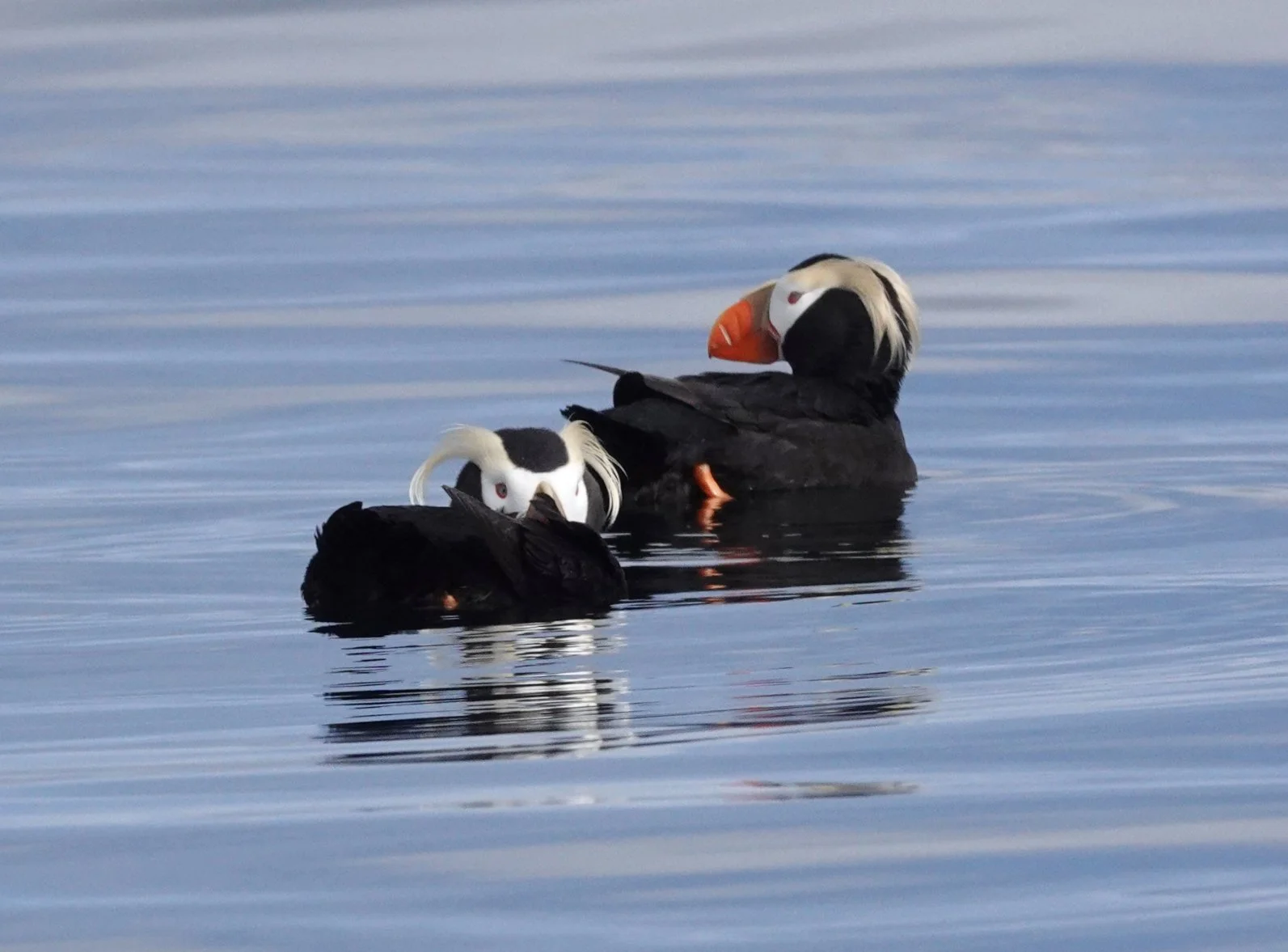
Tufted puffins off Forrester Island. Nothing raises my spirits during a long paddle more than the cheerful face of a tufted puffin.
Cassin’s auklet off Forrester Island. The Cassin’s can be identified even at long range or in poor light by its upright posture, round head, and pale “eyebrow.”
Rhinoceros auklet off Forrester Island. Forrester is the northernmost of the eight major breeding colonies which house approximately ninety-five percent of the rhinoceros auklet’s North American population.
Parrot Point, Baker Island. Landfall was a welcome event after eleven hours in the kayak, but the steep shoreline here at the south end of Dall Island afforded only a few places to land.
Cape Muzon is the southernmost tip of Dall Island. In fact, it is the southernmost point in southeast Alaska. The international boundary runs just a few feet offshore of the islands off Cape Muzon.
The cape receives the full force of winds and swells from the ocean, plus the full force of the famously strong currents of Dixon Entrance, plus additional outflow from Cordova Bay, between Dall Island and Prince of Wales Island. Nautical charts of the cape are thick with various squiggly, jagged lines denoting breakers and tide races. The Coast Pilot recommends giving it a berth of “at least one mile.”
It seemed unwise to attempt such a hazardous area at the end of an already long day coming from Forrester Island. Instead, I camped at Wolk Harbor at the southwestern corner of Dall Island and then rounded Cape Muzon on the tail end of the next morning’s flood. Even at slack water, the currents around Cape Muzon were swirling around at high speeds and in unpredictable directions.
Life was easier on the east side of Dall Island than the ocean side. Swells here were non-existent, and the fetch of the wind was only a few dozen miles instead of a few thousand. The shoreline was indented with bays, and the channels were studded with islands, all of which offered easy landings and camping wherever I wanted. I holed up in deep, protected Datzkoo Harbor for several days to wait out the windstorm whose forecasted arrival had driven me from Forrester Island ahead of schedule.
A pair of sandhill cranes flew into Datzkoo Harbor a few hours after I arrived. The cranes settled in on a patch of grass on the far side of the stream where I was camping. At first, I thought their squawking was just mindless noise, but I soon learned to take it seriously. The only time the cranes squawked was when something interesting was happening. Often, they squawked to announce the beginning of a courtship dance, which involved much bowing and jumping and craning of the neck. One time, they squawked to alert a third crane, flying high over the island, of their whereabouts, just in case the newcomer needed a safe place to land. On yet another occasion, they squawked to announce the arrival of a black bear on our shared beach.
Alerted by the cranes’ calls, I hurried out of the forest to confront the bear. I shouted and waved my arms to demonstrate my large size and my firm resolve to possess this beach. Not the human to tangle with, bear. I hoped the bear would take the message and leave in peace.
The bear watched my performance and was completely unimpressed. It shuffled over to a nearby tree, reared up on its hind legs to demonstrate its own awesome height, and reached overhead to break off a tree branch with a loud snap, an irrefutable display of strength. Convinced that the matter had now been settled in its favor, the bear began scratching its back against the trunk of the tree to show me how relaxed and unafraid it was.
All I could do was increase my own noise and aggression. A bluff, of course, but convincing so long as it wasn’t called. I picked up a branch of my own and began whacking it loudly against driftwood logs to show the bear that I, too, was capable of destroying harmless vegetation. As my clamor intensified, the cranes stopped squawking at the bear and started squawking at me. Apparently, this deranged human was actually the real threat on this beach.
It seems unlikely that I ever managed to frighten the bear, but I did manage to ruin its day. How could anyone enjoy a nice back-scratching session when there was some maniac pacing back and forth, yelling and waving a stick? The bear turned around and slowly walked back the way it had come, stopping from time to time to rear up and yank on branches overhead, just in case I had forgotten what a large and potent animal I was dealing with.
After that, the cranes were not just my neighbors. They were my friends. I went out of my way to avoid disturbing them. In the four days I spent at Datzkoo Harbor, I never once crossed to the cranes’ side of the stream, lest they fly away and leave me without any warning of the bear’s return. When I finally climbed into my kayak and paddled off, the cranes gave me one last, farewell squawk—or perhaps it was a call to inform the bear that the riffraff had been cleared out and it was now safe to return to the back-scratching tree.
Low tide and rain clouds in Datzkoo Harbor. Everything to the left of the stream was reserved for the sandhill cranes.
Breaking up chunks of puerh, Datzkoo Harbor. My meals were simple, but my tea was fancy.
Rigged for rain, Datzkoo Harbor. Rush of wind in the treetops, patter of raindrops on the tarp.
Sandhill crane, Datzkoo Harbor. This is one of the most majestic birds in North America.
American black bear, Datzkoo Harbor. Some bears are fearful, other bears are fearless.
Bear on hind legs, Datzkoo Harbor. I was half-afraid the bear was going to challenge me to a pull-up contest.
Bears weren’t the only mammals I encountered. The seas around Dall Island were full of marine mammals. The most numerous were sea otters and humpbacks whales, both of which I saw nearly every day of the trip.
Many of the sea otters were carrying pups. To my surprise, there were more otters on the sheltered, eastern side of the island than on the ocean side. In my experience, sea otters usually prefer rougher waters, but these Alaskan otters did not.
The humpback whales were unusually active. Many of them were lunge-feeding, in which the whales would blow rings of bubbles underwater to corral a school of fish, then surge through the trapped school, mouths agape, to scoop up dozens of fish at a time. Sometimes, the whales’ bubble-blowing was so vigorous I could hear the gurgling a hundred meters away. Other whales would slap the surface of the water with their fins or even breach entirely out of the water, landing with immense splashes that sounded like cannon shots even from a distance of five miles (8 km) or more.
With the exception of Forrester Island, all the islands were overrun with deer, all of the Sitka black-tailed subspecies of the mule deer. I saw deer or their signs even on the smallest islands, such as the Channel Islands in Howkan Narrows, the smaller of which is only six acres (2.5 ha) in area. Deer would emerge from the forest in the mornings and evenings to collect salt from the beaches. Often I would find their skeletons in the woods, but whatever was eating them—presumably black bears or wolves—it wasn’t doing much to reduce the population. One of the reasons I always found campsite locations so easily was because the deer had browsed the undergrowth so heavily.
In all, I saw twelve species of mammal on this trip: eastern gray squirrel (seen in Seattle during the drive to the ferry), mule deer, American black bear, harbor seal, Steller sea lion, sea otter, northern river otter, American mink, humpback whale, killer whale, harbor porpoise, and Pacific white-sided dolphin (the latter three species seen from the ferry).
Sea otter off Baker Island. The otters and I both used kelp beds to mitigate the effects of wind-waves.
Humpback whale breaching in Kaigani Strait. Wherever a whale was breaching, I always gave it at least a mile of sea room to avoid a collision.
Humpback whale displaying ventral pleats, Howkan Narrows. This whale was foraging inverted on its back, filling its pouch-like jaws with water to capture as much prey as possible.
Humpback flukes off San Juan Bautista Island. Humpbacks generally display their flukes on the final dive of the set, when they make their deepest, longest dive.
Humpback whale lunge-feeding off San Juan Bautista Island. The whale’s hair-like baleen are visible, lining the interior of its rostrum.
American mink, Ham Cove. I searched Ham Cove for three hours, looking for a petroglyph reported to lie somewhere along the shore, but all I found was this handsome mink instead.
Sitka black-tailed deer, Ham Cove. The velvet on the antlers will come off at the end of summer, in preparation for the fall rut.
American black bear, Ham Cove. This mother and her cub were grazing on grass in the estuary of a small stream.
Summer comes late to southeast Alaska. Living in Seattle as I do, I’ve always considered the first of June to be the start of summer. In southeast Alaska, summer doesn’t get underway until a few weeks later. When I paddled around Dall Island in mid-June, many of the shrubs and undergrowth were still displaying their bright, springtime flowers. Ridge Island, an offshoot of Suemez Island connected to the larger island by a tombolo, was a particularly rich field for floriculture.
Songbirds sang in the forest starting an hour before dawn each morning and continuing till an hour after sunset. Thrushes were by far the dominant voices in the chorus. All four species of west-coast thrushes were abundant, but the most abundant was the Swainson’s thrush. Its distinctive, spiraling song was the musical motif of the trip.
Northern cinquefoil, Baker Island. This coastal flower is able to grow on practically no soil at all.
Bearberry honeysuckle, Ridge Island. This was the only species of honeysuckle I encountered on this trip, but it was widespread throughout the islands.
Pretty shooting star, Ridge Island. It was a surprise to find this drought-tolerant flower in as rainy an environment as southeast Alaska.
Red columbine, Ridge Island. I had hoped to watch a rufous hummingbird visit this spectacular red flower, but even though there were plenty of hummingbirds, they didn’t seem interested in the columbines.
Bunchberry, Ridge Island. When an insect lands on the center part of the flower, the center bursts open explosively and showers the insect in pollen.
Swainson’s thrush, McFarland Islands. This juvenile was less wary of humans than the adult birds were.
Dall Island and its surrounding islands have been inhabited by people for many thousands of years. However, it would be a mistake to think that the identities of the inhabitants have not changed during all that time. Like all nations everywhere, the Indian nations inhabiting these islands migrated, conquered, advanced, retreated, intermarried, amalgamated, seceded, and otherwise evolved over the centuries.
Beginning sometime in the middle of the eighteenth century, Indians from Haida Gwaii migrated across Dixon Entrance and began to colonize the southeast Alaskan islands, sometimes at the expense of other Indian nations who were already present. The tribes who migrated eventually came to call themselves the “Kaigani Haida,” to distinguish themselves from the Haida who remained on Haida Gwaii. The Kaigani Haida, in their turn, were colonized by Europeans and Americans who arrived on the southeast Alaskan islands only a few decades after the Haida themselves.
Over the course of the nineteenth and twentieth centuries, under the pressure of relentless economic, social, and political changes to their society, the Kaigani Haida gradually abandoned the majority of their villages. Much of the population was lost to periodic epidemics of smallpox, which further reduced the viability of smaller settlements. Today, almost all the people, indigenous and non-indigenous alike, have consolidated onto Prince of Wales Island. The abandoned villages on the outlying islands west of Prince of Wales have been left to decay into the rainforest.
I visited several of these ancient cultural sites. At some sites, I found no trace of human settlement. At others, I found extraordinary relics.
The most amazing site was a cave whose ceiling and walls were covered in dozens of ochre pictographs. Motifs included faces, canoes, and animals. The paintings were so subtle that on my first walk through the cave, I did not notice any pictographs. Only upon a second, closer, slower examination did the pictures reveal themselves.
House pit, Dall Island. During the late eighteenth and early nineteenth centuries, this site was a major village where Haida would trade sea otter furs to American “Boston men,” who would transport the furs onward to Imperial China for sale.
Totem pole, Long Island. Most totem poles were removed from the village sites during the early twentieth century, some by permission, others by theft, but this ancient, thoroughly decayed, and now-leaning pole remains in situ at a village site to this day, although its motif is no longer recognizable.
Cave painting of sculpin. This pictograph in the ceiling of the cave was the first one I noticed, and it alerted me to the presence of dozens more.
Cave painting of face with arms. The face is almost identical to the sculpin face, above, but of course, sculpins do not have arms.
Sun or eyeball motif painting over white crystalline calcite formation. Several of the pictographs incorporated natural features of the cave’s walls and ceiling into the designs of the paintings.
Cave spider suspended from ceiling. Never stand up too quickly inside a cave.
Other than the ocean current north of Forrester Island, which was more demoralizing than dangerous, the only significant current I encountered was through the Tlevak Narrows at the north end of Dall Island. I was able to fight the flood to within a couple miles of the narrows, but eventually the current won out and I was forced to pull over to a beach to wait a couple hours until slack. I re-entered the narrows, only to be clobbered by the sea breeze, which rose to fifteen or twenty knots each afternoon and did not abate until evening. On days when I didn’t get an early enough start, the sea breeze always made for arduous travel. I ended many days with my face soaking wet from spray flying off the wind-waves.
Life on the water could sometimes be tough, but life on shore was never anything but serene. As it became more and more apparent that I was on track to finish the trip ahead of schedule, I began spending more and more time relaxing ashore. Wherever possible, I camped on small to medium-sized islands to minimize my exposure to bears, the only thing capable of disturbing my repose.
Alex reading in Channel Islands. Even during a spring tide, at least a small part of the tombolo connecting the two islands remained above water.
Kayaking McFarland Islands. I tried sleeping out under the stars in the McFarland Islands, but condensation gathering on my down sleeping bag soon drove me to set up a tent.
Looking northward up Tlevak Strait from north end of Long Island. This archipelago doesn’t have a name on the map, but it is so beautiful I named it the “Alex Islands.”
Sunset at Ridge Island. I camped on the south side of the island to shelter from the relentless northwesterly wind.
Alex camping in Ballena Islands. I spent the last night camped just a couple miles outside town so I could meet my friend with the pickup truck the following afternoon when he got off work.
I regret not dragging myself out of the tent in the middle of the night on Forrester Island to watch the seabirds attend their burrows. Other than that, the trip could not have gone better. It was so encouraging to see such vast numbers of puffins, murrelets, and Cassin’s auklets on the ocean. The whale behavior was the most active I have ever seen. The archeological sites were exhilarating, especially the paintings in the cave. Any of these sights would have been worth the journey on its own. To see them all together was a rare kind of joy.
—Alex Sidles